Why conservationists, local groups are opposing Ksh.4.4B Ndunyu Njeru-Ihithe road across Aberdares

By
Ayub Adan
Plans
to construct a mega highway through the Aberdare National Park hit a new roadblock after the Conservation Alliance of
Kenya (CAK) filed an appeal at the National Environment Tribunal earlier this month.
Conservationists
and community groups are raising concerns about the Ndunyu Njeru-Ihithe road on
environmental and economic viability grounds, urging a more sustainable
approach to the Ksh.4.4 billion project.
The
controversial road is set to connect Nyandarua and Nyeri counties, where the
Aberdare Ranges sit.
But
while a section of the community and leaders view the road as a development
boon, the lobby groups maintain that the call to stop the section of the Mau
Mau Road that threatens to split one of the few remaining connected ecosystems
in the country is not a development-versus-conservation war.
“It
is not a choice that we have to make. This is not a case of development versus
conservation. There are better options
and better alternatives that have better economic returns for this connection
of the County of Nyeri and the County of Nyandarua, Nakuru and Laikipia that
would actually be more economically viable and would also assist the
community,” says Nancy Githaiga, the Country Director of African Wildlife
Foundation Kenya.
“At
what cost to the environment will this road be done? Is it sustainable? The
Aberdare is a critical water catchment. This means that the destruction of this
ecosystem will affect all of us, because
what happens in the Aberdare does not stay in the Aberdare, making the
preservation of this critical ecosystem, my business, Your business and our
business,” adds Christine Mwangi, the Regional Coordinator of Africa Sustainable
Investments and Infrastructure Programme at WWF-Kenya.
Should
the proposed project come to fruition, the multi-billion stretch
is poised to become among the highest roads in the country with its highest
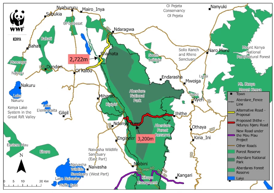
elevation being 3,200 meters above sea level.
“It
means that you will have a steep climb on one side and steep descent on the
other side, which will make that road not practical for canters that will be
forced to use that road to transport goods from one county to the next county.
It will not be a practical road by all means,” Christian Lambrechts, the Executive
Director of Rhino Ark said.
The
road comprises a 52-kilometre stretch traversing Ihithe-Ndunyu Njeru main
section, a 12-kilometer Njengu-Treetops gate-Amboni stretch, a 3.6-kilometre
Ihithe-Kiamutiga-Mukarara, a 2-kilometre Ark gate access road and a
21-kilometer Munyaka-Koinange-Heni Mwedandu Njoma-Weru stretch.

“On
the contrary, the alternative route promises to benefit a larger population, so
why not upgrade the alternative?” posed George Kiragu, a resident.
“The
alternative road lies outside the Aberdare Electric fence. And this means that
there will be no conflict with wildlife. The wildlife is inside the fence,”
added Lambrechts.
The
proposed alternative route, the Ndaragwa-Pesi-Shamata-Kariamu road is in bad
state. It is argued that this option is not only cheaper but also connects more
people to the tarmac and is five kilometres shorter when linking Olkalau and
Nyeri, the county headquarters for Nyandarua and Nyeri respectively.
“We
have a big connectivity problem from Gieterero-Mastoo and Kariamu. To get to
Olkalau, the county headquarters, we have to go to Wiyumiririe then Nyahururu, which
is actually Laikipia,” Charles Kimaru, a resident of Nyandarua’s Pesi area says.
The
Ndunyu Njeru-Ihithe Road would also be a day road subject to the 6 am to 6 pm
operational hours, as per Kenya Wildlife Service (KWS) park rules and
regulations.
“As we strive towards a 24-hour economy, confining connectivity to just 12 hours seems counterproductive and contradictory to our goal of achieving a sustainable 24-hour economy and optimal connectivity as a country,” says Dominic Walubengo, the Chairman of the National Environment Civil Society Alliance of Kenya.
NEMA Director General Mamo Boru approved the construction with a caveat that the width of the road be reviewed downwards from 40 to 25 meters, specifically in areas traversing the Aberdares forest reserve and national park.
The Kenya Forest Service (KFS), Kenya Wildlife Service (KWS) and NEMA had initially withheld approval for the project, citing that the decision was based on the potential disruption of the Aberdare ecosystem.
Want to send us a story? SMS to 25170 or WhatsApp 0743570000 or Submit on Citizen Digital or email wananchi@royalmedia.co.ke
Comments
No comments yet.


Leave a Comment