Inside the space agency that will put Kenya on the world map after Taifa-1 satellite launch

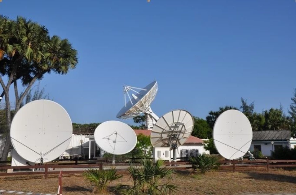
A file image of the Luigi Broglio-Malindi Space Centre. PHOTO|COURTESY
The Kenya Space Agency (KSA) is strapping up to initiate its
first satellite launch into space set to take place on April 11, 2023, in Vandenberg
Base, California, USA.
The satellite, an operational 3U Earth observation satellite named Taifa-1 satellite, will be launched with the aid of Space Exploration Technologies Corporation (SpaceX) aboard its launch vehicle Falcon-9 Rocket.
In a statement dated April 3, KSA director Hillary Kipkosgey stated that the mission is designed to provide precise and timely earth observation satellite data to stakeholders in the diverse fields of application including agriculture and food security.
The satellite will provide data for decision support to agriculture and food security, natural resources management and environmental monitoring among other details.
On his part, Defence Principal Secretary (PS) Patrick Mariru, who will also be part of a Kenyan delegation travelling to US to witness the launch, stated that the mission will provide precise satellite data to stakeholders in the agriculture and food security fields.
The promising brainchild
When KSA was established in 2017, there was only one agenda in mind; to promote, coordinate and regulate space-related activities in the country.
The establishment was stimulated by the Cabinet's approval of the Kenya Space Policy, the Kenya Space Strategy and the Kenya Space Agency Order in 2016.
KSA then formed a Board of Directors was appointed in September 2018 where they geared up towards achieving its mission of establishing centres of excellence in space science and enter into mutually beneficial agreements with other agencies and governments to further national exploitation of space as a resource.
PS Mariru says that the agency's engineers buried their heads in the satellite's production, a build that took 2 years to finalize and was fairly cost-effective.
"It's only the parts that we sourced from external partners but in terms of fixing it was done by our engineers," said PS Mariru while addressing the press on Tuesday.
"The cost has been modest. To develop this vessel it has cost Kenya Ksh.50 million."
With the huge foreseen advantage the satellite will hand to Kenya, PS Mariru noted that the nation will be able to independently access data for decision support to combating climate change and improving agriculture and food security.
The advantage will also allow Kenya to exchange or borrow notes from top commercial space entities, such as the National Aeronautics and Space Administration (NASA) and SpaceX.
Building on an
esteemed foundation
Kenya has been involved in various space initiatives through international agreements and collaborations over the past 50 years.
It's equatorial location and coastline make it an ideal spot for equatorial space launches, and the country seeks to establish a launch facility in this area to contribute to national development and the space economy.
KSA's course operates on the backdrop of a solid engagement by Kenya into matters of outer space which began in 1964 when the San Marco Equatorial Range, now known as the Luigi Broglio-Malindi Space Centre was established.
It was formed through a collaboration between Kenya and Italy. The centre was composed of a sea launch platform and a land-based telemetry, tracking and command station as well as a logistics base.
Since its establishment, a total of 27 launches have been conducted at the facility between 1964 to 1988. It currently acts as a launch support and tracking, as well as satellite data acquisition.
The station picked the "first signals" to Earth, forming the first point of contact between the vehicle and its observers during the critical mission.
It is against this backdrop that KSA has a seamless genesis into its operations upto achieving its first milestone of launching its own satellite.
Climate change
watchman
Since its operationalization in 2018, KSA has conducted several activities in the implementation of its mandate from promoting space science, education and outreach to developing space systems and applications to support decision-making.
According to KSA, they launched the Monitoring for Information and Decisions using Space Technology (MIDST) project in 2020 which aims to improve decision-making through use of Earth observation data in natural resources management, urban planning and disaster response.
During the first phase of the project, analysis was conducted on the Aberdares forest between 2016 and 2020, while the second phase focused on monitoring the urban growth rate for Nakuru Municipality and its surroundings from 1989 to 2020.
KSA has also worked with both National and County governments in developing capacity to utilize space-derived data for decision support.
Thus far KSA has worked with the Ministry of Environment and Natural Resources through the Kenya Forestry Services to develop products that monitor the extent and characterize the forest cover in the Aberdares, Ngong and Kibiku Forests.
It also works with the Ministry of Agriculture, through the Agriculture and Food Authority in developing the capacity of AFA to utilize space-derived data and analytical tools to carry out the characterization of fields under crops for crop mapping, crop condition monitoring and crop yield estimation.
Since 2020, the agency has been partnering with local universities and start-ups through its research grant programme to develop national human capacity in space science and technology.
KSA says that they aspire to transform the nation in unison with Kenya Vision 2030. They noted that they aim to play a significant role in the goals of this vision by making strategic investments in satellite systems and launch facilities.
Want to send us a story? SMS to 25170 or WhatsApp 0743570000 or Submit on Citizen Digital or email wananchi@royalmedia.co.ke
Comments
No comments yet.


Leave a Comment